


Lipari
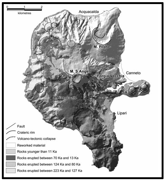
Simplified geological map of Lipari island. Modified after Tranne et al. (2000) and Calanchi et al. (2002a).
Lipari covers an area of about 38 km2 and is the largest of the Aeolian islands. Detailed volcanological investigations and geological mapping recognized various cycles of activity. Early exposed products (223 to 127 ka) consist of sub-aqueous and subaerial basaltic andesitic and andesitic lavas and pyroclastic rocks. These are followed by high-K andesites and minor dacites and shoshonites with an age of about 120 to 80 ka. Successively, strongly explosive eruptions (70 to 13 ka) formed several large brown-coloured high-K calc-alkaline to shoshonitic pyroclastic deposits (the so-called Brown Tuffs ), alternating with silicic lava flows and domes. Brown Tuffs probably originated from eruptive centres located between Lipari and Vulcano. The final activity at Lipari (11 ka to 580 AD) gave rhyolitic obsidian lava flows, domes and pumices. The oldest and more mafic activity appears to be associated with the E-W fracture system, whereas younger shoshonitic and rhyolitic magmas were erupted primarily along the NWSE tectonic alignment of the Tindari-Letojanni-Malta fault system.
♦ The volcanic activity of the first period (Paleolipari: from about 223,000 to 150,000 years BP) is related to the activity of several monogenic centres (scoria- and lava-cones) located along the western coast in correspondence with a NW-SE-oriented tectonic lineament. They are characterised by prevailing strombolian (scoriaceous deposits) or effusive activity (lava flows) and very subordinate hydromagmatic activity (tuff and lapilli tuff): their products display CA basaltic-andesite compositions. Almost contemporaneously, and with similar volcanological and compositional features, the twin volcanic centres of Monterosa and the monogenic centre of Timpone Croci, begin their activity in the central-eastern sector of Lipari. All these centres, actually strongly eroded, covered by younger volcanic products, crossed by dykes and locally highly fumarolized, represent the remnants of the Paleolipari apparatus.
♦ The volcanic activity of the second period (Monte Chirica I and Monte S.Angelo I centres: from less than 150,000 to 127,000 years BP) begins in the central sector of Lipari with the emplacement of volcanic products related to the large Monte Chirica stratovolcano. To the early explosive activity of Monte Chirica (Monte Chirica I) must be ascribed the thick and well stratified sequence of massive tuffs and scoriaceous lapilli tuffs cropping out along the steep canyons going down from the top of Monte Chirica to the Acquacalda seashore; The early volcanic activity of the huge Monte S.Angelo stratovolcano (Monte S.Angelo I) represents the first extensive example of magma-water interaction testified by the emplacement of hydromagmatic, well stratified, HKCA andesitic pyroclastics cropping out near Timpone Ricotta and in the Timpone del Corvo - Marina di Porto Salvo area (the tourist harbour of Lipari). The sequence of lapilli tuffs and ash tuffs represents the hydromagmatic phase (i.e. a prevailing explosive phase), followed by an effusive phase characterised by the emplacement of thick HKCA andesitic lava flows.
♦ After a period of quiescence, indicated both by a well evident subaerial erosional surface and by marine erosional surfaces with related marine conglomerates, the volcanic activity starts again: the third period comprises a time span ranging from 104,000 until to about 90,000 years BP This period (Monte S.Angelo II and III, Monte Chirica II) is characterised by the emission of volcanic products with fairly similar composition (HKCA andesite) but with very different eruptive style as testified by the hydromagmatic - effusive contemporaneous activity.
♦ The volcanic centres active during the fourth period are located in the southern sector of the island: their white pyroclastic products are recognisable owing to the presence of peculiar intercalations of brownish pyroclastic deposits of exotic provenance (Brown Tuff). The volcanic activity (from 42,000 to 20,300 years BP) is related to the three centres of Punta del Perciato, Falcone and Monte Guardia characterised by similar schemes of evolution: early hydromagmatic explosive episodes (surge and. fall deposits) are followed by the outpouring of highly viscous rhyolitic domes. The domes of Punta del Perciato centre, almost uniquely visible under the present sea level, crop out discontinuously along the south-western coast, at the base of the cliff; the domes of Falcone centre, Capparo and Capistello, crop out over the previous domic products in the southernmost portion of Lipari, whereas the domes related to the Monte Guardia centre are located in the high south-western sector (S.Lazzaro, Monte Guardia, Monte Giardina) and in the south-eastern one of Lipari (Castello, S.Nicola, Punta S.Giuseppe).
♦ The volcanic activity of the fifth period (between 16,800 and 1,400 years BP), is confined to the north-eastern sector, and is related to the activity of four centres: Canneto Dentro, Gabellotto, Monte Pilato and Forgia Vecchia. The activity of Canneto Dentro is testified only by limited outcroppings of pumiceous pyroclastic breccia and of a squat rhyolitic dome. The activity of Gabellotto begins with the emplacement of large amounts of white, pumiceous pyroclastics (dry surge deposits) leading to the building of a tuff ring, and ends (between 11,400 and 8,600 years BP) with the outpouring of a huge, obsidianaceous, rhyolitic lava dome. After a volcanic inactivity about 3,000 years long, marked by the formation of an orange-red paleosol, the activity of Monte Pilato, located in the northernmost sector of Lipari, starts with a series of explosive eruptions leading to the building of a large rhyolitic pumice cone from which the obsidianaceous and rhyolitic lava flow of Rocche Rosse, about 20 meters thick, overflows reaching the sea nearby Acquacalda. The last volcanic products are related to the activity of Forgia Vecchia (about 1,400 years BP) and consist in the emplacement of few white, pumiceous pyroclastic deposits followed by the outpouring of a viscous, bilobate, rhyolitic lava flow: this is the last demonstration of volcanic activity on Lipari.
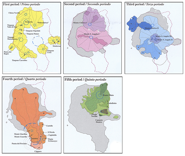
Magmatic activity at Lipari. From Lucchi et al., (2008).
Some authors suggested that fractional crystallisation was a main magma evolution process. However, magma contamination plus mixing among various types of melts have also played important roles in the petrogenesis of the Lipari magmas. Crustal contamination was particularly strong in cordierite-bearing andesites, as indicated by petrographic and radiogenic isotope data. According to these authors, subalkaline to K-rich melts were generated in a stratified mantle, characterised by decreasing degree of metasomatism with increasing depth; early large degrees of partial melting of depleted deeper mantle generated tholeiitic magma, whereas late melting of uppermost anomaouslithospheric mantle produced K-alkaline melts. Potassic mafic melts intruded into the volcanic system and mixed with tholeiitic magmas, causing the steep increase in potassium which is observed in the Lipari rocks. Upward migration of mantle melting processes was related to increase of isotherms within the upper mantle, as a consequence of doming beneath Lipari. Magma emplacement in the crust also generated anatexis, with formation of rhyolitic melts. However, Gioncada et al. (2003) noticed that isotopic compositions (especially Pb) of rhyolites are different from those of the Calabro-Peloritano basement, concluding that a generation of acid melts by crustal anatexis is unlikely. Therefore, it has been suggested that rhyolitic magmas formed by fractional crystallisation, starting from parental andesitic to latitic melts, accompanied by crustal assimilation and mixing with latitic magmas.
Bibliography
• Peccerillo. A. Plio-Quaternary Volcanism in Italy. (2005)
• Gioncada. A, Mazzuoli. R, Bisson. M, Pareschi. M.T (2003): Petrology of volcanicproducts younger than 42 ka on the Lipari-Vulcano complex (Aeolian Islands,Italy): an example of volcanism controlled by tectonics. J Volcanol Geotherm.
• Tranne. C.A., Calanchi.N., Lucchi.F., Rossi.P.L. Geological Sketch map of Lipari
.jpg) Pyroxene and plagioclase crystals and Calcite fillng a vesicle. XPL image, 2x (Field of view = 7mm) |
.jpg) Pyroxene and plagioclase crystals and Calcite fillng a vesicles. XPL image, 2x (Field of view = 7mm) |
.jpg) Pyroxene and plagioclase crystals and Calcite fillng a vesicles. XPL image, 2x (Field of view = 7mm) |
.jpg) Pyroxene and plagioclase crystals. XPL image, 2x (Field of view = 7mm) |
.jpg) Pyroxene and plagioclase crystals. XPL image, 2x (Field of view = 7mm) |
.jpg) Pyroxene and plagioclase crystals. XPL image, 2x (Field of view = 7mm) |
.jpg) Pyroxene crystal. PPL image, 10x (Field of view = 2mm) |
.jpg) Plagioclase crystals and Orthopyroxene with Clinopyroxene rim. XPL image, 2x (Field of view = 7mm) |
.jpg) Orthopyroxene with Clinopyroxene rim. XPL image, 10x (Field of view = 2mm) |
.jpg) Calcite fillng a vesicle. XPL image, 2x (Field of view = 7mm) |
.jpg) Calcite fillng a vesicle. XPL image, 2x (Field of view = 7mm) |
.jpg) Plagioclase crystal with Sieve texture. PPL image, 2x (Field of view = 7mm) |
.jpg) Pyroxene and plagioclase crystals. XPL image, 2x (Field of view = 7mm) |
.jpg) Pyroxene and plagioclase crystals. XPL image, 2x (Field of view = 7mm) |